
Prof. Dr. Anda Angéla, MATE Georgikon Campus, Keszthely
18 June 2025
The amount of energy delivered by the Sun is not evenly distributed across the globe; it is very high at low latitudes, near the Equator, and gradually decreases as it moves away from the Equator towards the poles. This divergence is reflected in high temperatures near the Equator and increasingly low temperatures further away. To compensate for this temperature differential, air currents are formed, which transport not only heat but also the moisture in the air, linking the energy and mass flow of the atmosphere. The high temperatures at low latitudes, in the southern seas and oceans, induce strong evaporation, which ‘fills’ the north- and southward air with moisture. It is not widely known that this also means energy transport, as the energy used for evaporation (near the Equator) is released in the air mass transported north and south in the process of precipitation formation, warming the place of precipitation. This is also the case in our temperate zone. In this area too, the energy source of the air from lower latitudes is twofold; it not only provides heat but also brings extra energy to our region by precipitating the moisture in the air mass. The energy associated with changes in water content, known as latent heat, is realised in the process of precipitation formation (cyclone).
From the above reasoning, it is clear that energy and mass transport (water vapour) are inextricably linked. In areas where energy is abundant, the air is also the most moisture-absorbent; the warmer the air, the more moisture it can hold until saturation is reached. Air humidity also affects energy input through cloud formation. High humidity will eventually lead to condensation and thus cloud formation, which in turn is a direct barrier to solar radiation reaching the surface. The missing link to understanding this process is the important source of atmospheric moisture, evaporation. In Hungary, it is estimated that about 90% of precipitation evaporates back into the atmosphere. As the largest terrestrial energy user (about 70% of total energy), evaporation acts as a key factor in transporting and balancing water and energy. In addition to maintaining the Earth’s atmosphere, a fraction of precipitation is used for other purposes (agriculture, domestic use, industry, etc.). Depending on the surface from which evaporation occurs, water loss from plants is transpiration, or evapotranspiration with soil, and evaporation from all inanimate surfaces (seas, lakes, just soil alone, but even drying clothes).
We tend to attribute the negatives of global warming only to rising temperatures, but if evaporation decreases due to water shortages, the energy distribution in the atmosphere is immediately disrupted due to the lack of atmospheric moisture. As long as warming increases evaporation linearly, the atmosphere’s capacity to hold water vapour increases exponentially with air temperature. Evapotranspiration from plants is estimated to be globally dominant (60%). The role of evapotranspiration extends far beyond maintaining plant life functions. Without the conversion of inorganic matter into organic matter at the base of the food chain (of which water is a fundamental component), the order of life on Earth would be disrupted. Without the evapotranspiration of plants, the microclimate of our habitat would be less enjoyable; think of the almost entirely plant-free microclimate of deserts. It is no coincidence that making urban environments more pleasant is often achieved by increasing the amount of green area.
In the domestic context, the moisture available for evaporation during drought-prone months is insufficient. In a warmer period, the increased water demand generated by higher air temperatures cannot be met by natural moisture, and there is little moisture in the atmosphere to form cloud cover that can meaningfully reduce the amount of solar radiation reaching the surface. The resulting moisture deficit would then not only reduce the energy input from solar radiation, but increase it, contributing to the cloud/precipitation deficit as a self-exciting process. A summer warm-air intrusion dries out the surface first, which in the absence of clouds further enhances the warming, now without the possibility of moisture replenishment and thus without the possibility of clouds and later precipitation.
The phenomena that lead to droughts do not usually end well. Sooner or later, the warm air begins to cool after a drought, and the huge amount of moisture stored in it condense. During the phase transformation of water vapour, the energy required for evaporation (evaporative latent heat) is released, which excites cyclone formation, where the air is directed from the edges of the pressure gradient towards the centre. This concentration concentrates the moisture and energy in a smaller area and favours the development of extreme weather phenomena (heavy rain, thunderstorms, flash floods, etc.).
During the summer of 2024, the Northern Hemisphere, including Europe, experienced strong warming, which inhibited the formation of clouds that could have reduced the warming effect. The global circulation system was also altered: the desert landfall shifted further north towards the Mediterranean, blocking the normal circulation systems in the tropics and temperate zone, disrupting cyclone formation that brings precipitation. The result: numerous heat waves across Europe. Three of them hit our country, effectively setting the weather pattern for the summer of 2024 from mid-June to early September. The most severe was the one in August 2024. The last heat wave occurred between 6 August and 4 September, when hot air mass from the south was further warmed by a similar hot air mass from Asia Minor, which settled in the Carpathian Basin. The heatwave was finally brought to an end by Cyclone Boris, bringing flash floods in several countries alongside the easing.
As a local effect of the global history described above, HungaroMet data shows that many records will be broken in Hungary in 2024. The hottest year of the 1901 measurement period was 2024 (13.6°C), which beat last year’s record-breaker, the mean temperature of 2023, now in second place, by 0.7°C. The climate norm (1991-2020), the 30-year most likely mean temperature closest to us in time, is 10.72°C. The difference between the 2023 and 2024 mean temperatures and the climate norm is too large. In addition to the annual mean temperature, there are numerous other temperature records for other periods (record for the hottest month: July, second hottest: August, fifth and eighth hottest: June and April). The mean values for the non-record months not listed were generally ‘only’ 1-2 degrees °C above the climate norm. In summary, all seasons except autumn have been the warmest since HungaroMet started measuring.
The precipitation data did not show a much better picture either, with 16% less than the climate norm last year (517.4 mm). The temporal distribution of the element was almost always below the long-term average. There was also a record-breaking month, with July being the seventh driest July and August the ninth driest August since measurements began in 1901. In addition, precipitation deficits in February, March, July, August, November and December were still outstanding. The spatial distribution of precipitation was in line with the previous national trend. In our mountainous areas and in the western border regions of the country, annual precipitation exceeded 700 mm. In the other parts of the Transdanubian region, slightly more than 500 mm fell. The southern and eastern parts of the Great Plain received the least precipitation. The minimum was clearly in the southern parts of the Tiszántúl, where the annual amount was less than 400 mm.
The combination of temperature, precipitation and other site characteristics described above allowed the production of the drought map of the country for the last day of the third heat wave, 4 September 2024, published by HungaroMet on its website (Figure 1). The figure shows the continued expansion of traditional drought-prone areas even if water scarcity was slightly less severe this year than in 2022. The two drought situations are too close together in time, which may raise the question: when can we expect the next drought summer? What is certain is that the likelihood of extremes has increased markedly by today. It is likely that we cannot stop at asking this question, but must be prepared for the possibility of a repeat of last summer’s events at any time in the near future. Let us be prepared!
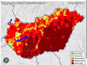
Figure 1 Drought conditions in Hungary during September 2024. (HungaroMet). The markings in the Figure are as follows: green – no drought; yellow – moderate drought; orange – severe drought; red – serious drought; brown – very severe drought.